Water mills at the island
|
A) The origin B) The left branch C) The right branch |
||||||||||||||||||||||||||||||||||||||||||||||||||||||||||
A) THE ORIGIN  Since the second century mills were
on the side of the Gianicolo that from St Peter in
Montorio steeply slopes down to the Tiber; they were
activated by the fall of the water that the emperor
Traiano had derived from the area of the Sabatini
mountains (pict. A1). Since the second century mills were
on the side of the Gianicolo that from St Peter in
Montorio steeply slopes down to the Tiber; they were
activated by the fall of the water that the emperor
Traiano had derived from the area of the Sabatini
mountains (pict. A1).During the Goth siege of Rome in 537 AD, Vitige ordered the aqueducts cut in order to prevent the arrival of drinkable water to the city; this lack of water also stopped the operation of the Gianicolo mills. These were reactivated, in a new position, only in the XVII century when Pope Paul V Borghese (1607-1612) built the aqueduct that still has his name (Acqua Paola) conveying water from the lake of Bracciano (pict. A2).  The forced inactivity of
the Gianicolo mills gave birth to the Tiber floating
mills: in fact, as Procopio of Cesarea testifies, the
Byzantine general Belisario, sent by the emperor
Giustiniano to garrison the city, used the river's
current to move the first floating mills. He anchored to
the banks two boats with a wheel between them; the
wheel, activated by the current, drove the millstones
located in the boats themselves. The forced inactivity of
the Gianicolo mills gave birth to the Tiber floating
mills: in fact, as Procopio of Cesarea testifies, the
Byzantine general Belisario, sent by the emperor
Giustiniano to garrison the city, used the river's
current to move the first floating mills. He anchored to
the banks two boats with a wheel between them; the
wheel, activated by the current, drove the millstones
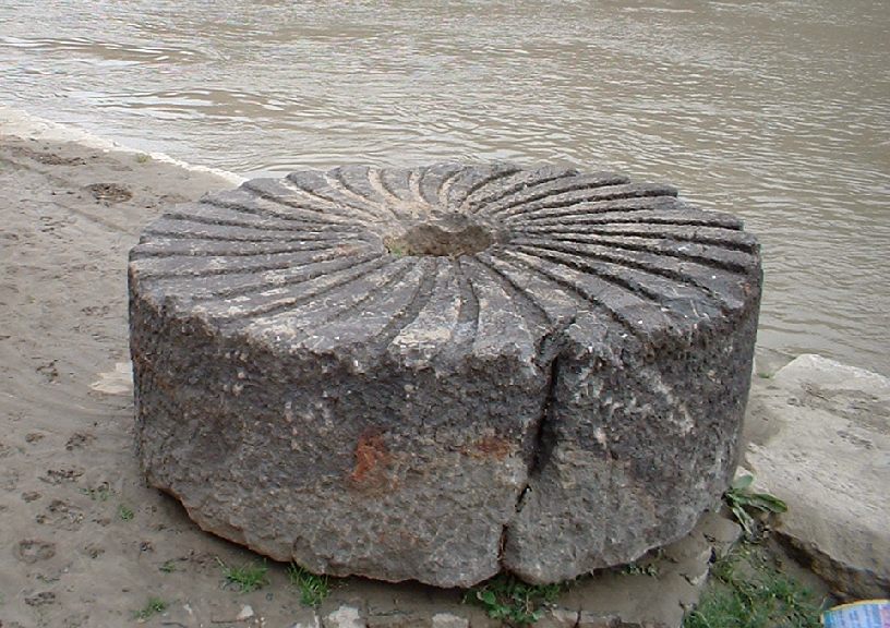
located in the boats themselves. The mills had been first located just downstream from Ponte Sisto, the bridge across the only part of the Tiber enclosed by walls on both sides and therefore protected from the military point of view; moreover this location is near the Gianicolo and this made the transport of the millstones easier.  From there the mills grew around the Tiber Island, thus becoming part of the Tiber landscape for more than 1300 years until the construction of the embankments. From some remnants recovered near the piers of the Ponte Neroniano, near Castel S.Angelo, (one millstone, a chain and some planks of the raft) it has been possible to reconstruct a scale model of the mill (pict. A3). B) THE LEFT BRANCH The oldest traces of the Tiber mills are found on the left branch of the river; it was, however, less used than the right one due to its reduced water flow. 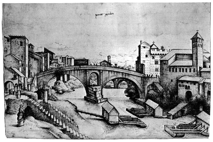 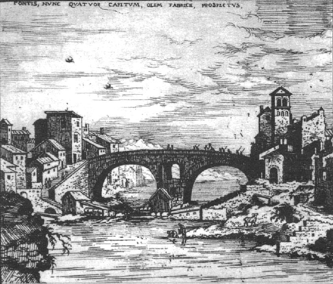 The first
textual references to the mills are found in texts of
the 1300s, but the first graphic evidence is a drawing
by "Anonymous Escurialensis" (after a drawing by
Giuliano da Sangallo), dated between 1485 and 1514
(pict. B1), that shows three mills on the Tiber's left
branch just upstream from the Ponte Fabricio, and an
engraving by Hieronymus Cock dated 1530-34 (pict. B2)
that shows two mills, also just upstream from the
Fabricio bridge, one anchored to the left bank and the
other to the island. The first
textual references to the mills are found in texts of
the 1300s, but the first graphic evidence is a drawing
by "Anonymous Escurialensis" (after a drawing by
Giuliano da Sangallo), dated between 1485 and 1514
(pict. B1), that shows three mills on the Tiber's left
branch just upstream from the Ponte Fabricio, and an
engraving by Hieronymus Cock dated 1530-34 (pict. B2)
that shows two mills, also just upstream from the
Fabricio bridge, one anchored to the left bank and the
other to the island.All later images show a single mill, or two placed side by side, but located upstream, on the Regola bank.  In
particular two mills are shown by Silvestro Peruzzi
(1564-65) and by Giovanni Maggi (1625) (pict. B3); Maggi
drew them not to scale and located in front of
S.Vincenzo and Anastasio at the Regola, further upstream
than where they probably really were. In
particular two mills are shown by Silvestro Peruzzi
(1564-65) and by Giovanni Maggi (1625) (pict. B3); Maggi
drew them not to scale and located in front of
S.Vincenzo and Anastasio at the Regola, further upstream
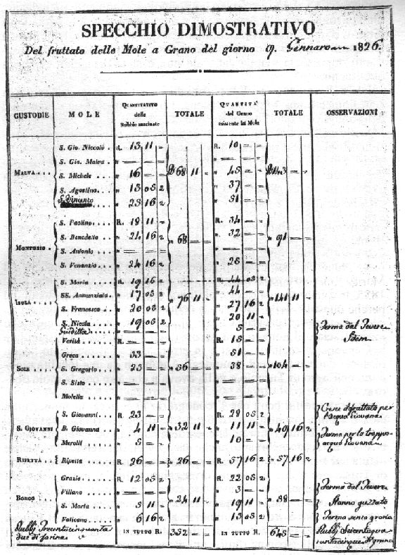
than where they probably really were. 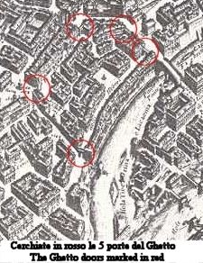 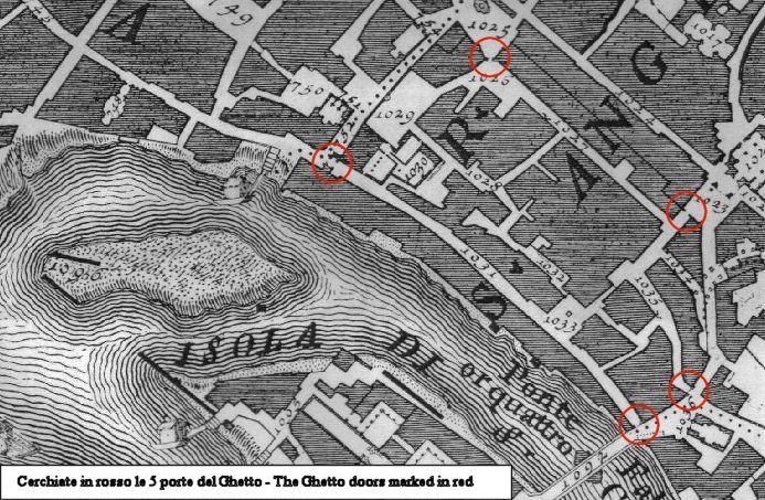 A single mill is indicated in the maps of Antonio Tempesta (1593), Matteo Greuter (1618), G.B.Falda (1676) (pict. B4) and G.B.Nolli (1748) (pict. B5). This mill is known (1620) as "mola di S.Andrea al Portone delli Hebrei" [mill of S.Andrea at the Door of the Jews], as it was located near one of the 5 doors, clearly visible in the Falda and Nolli maps, that enclosed the Jewish Ghetto constituted by Papal Bull in 1555. The doors were definitively unhinged only in 1848.  Andrea Chiesa, engineer from Bologna, appointed together with Gambarini to study the Tiber, also reported in 1745 that in the left branch of the river near the island there was only one mill, known as "Mola di Ghetto" [mill of the Ghetto], located in correspondence with the north end of the island and therefore near Monte Cenci as shown in the 1746 map (pict. B6). The last citation of this mill is dated 1810; the mill, therefore, completely disappeared in the beginning of the 1800s.  The last known mill on the Tiber's
left branch is the so-called "mola terragna" [mill with
foundations] located on the island (not floating). In a
census it was numbered as 43 and 44 of "Via delle
mole di S.Bartolomeo" [Street of the Mills of St
Bartolomeo]. Starting in 1826 it is found, under the
name of the "Giuditta" mill, in the records of the "Specchi
Dimostrativi" [Demonstrative Reports] of grinding
(see also para. D). Its location is shown on the
Lanciani map (end of XIX century - pict. B7) together
with the long wall of pilings which directs the flow of
the water to the mill. The last known mill on the Tiber's
left branch is the so-called "mola terragna" [mill with
foundations] located on the island (not floating). In a
census it was numbered as 43 and 44 of "Via delle
mole di S.Bartolomeo" [Street of the Mills of St
Bartolomeo]. Starting in 1826 it is found, under the
name of the "Giuditta" mill, in the records of the "Specchi
Dimostrativi" [Demonstrative Reports] of grinding
(see also para. D). Its location is shown on the
Lanciani map (end of XIX century - pict. B7) together
with the long wall of pilings which directs the flow of
the water to the mill.
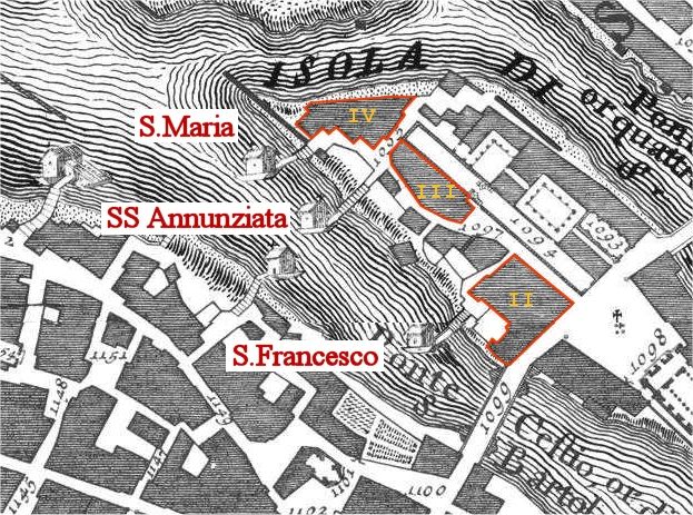
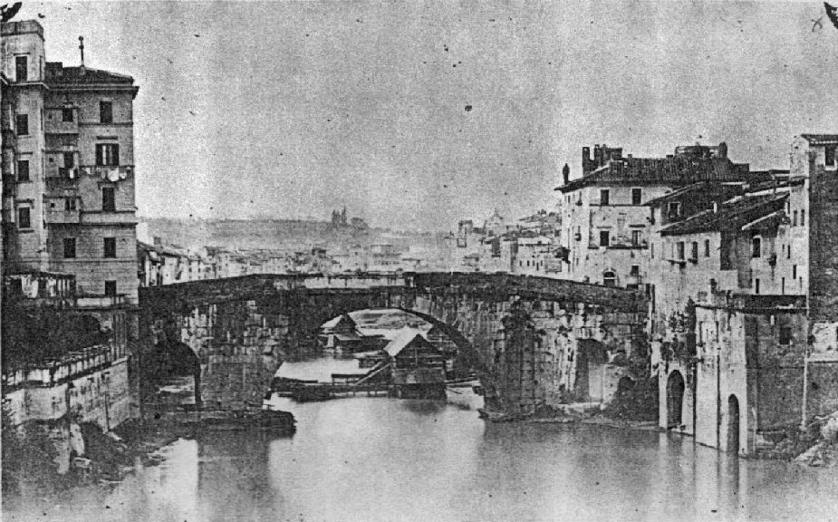
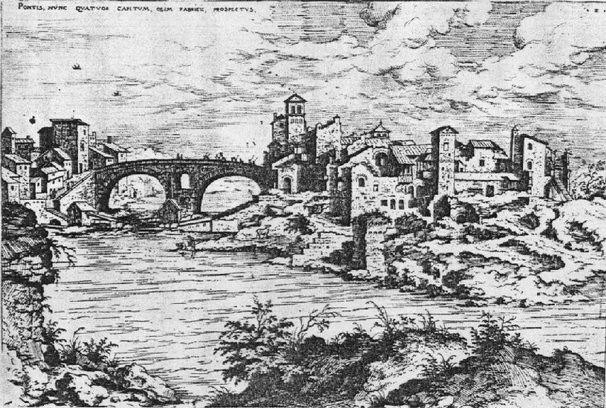
C) THE RIGHT BRANCH Many more mills have always been in the right branch of the river, due to the river's larger size and greater flow on that side; there the last mills were removed only during the construction of the embankments after the big flood of 1870. The Ponte Cestio was also known as "Ponte Ferrato" [bridge-with-iron] (see pict. E6) for the many mooring chains of the mills around it.  Often the
mills' moorings were broken by the strength of the
current, so it is not unusual to find in the old maps
only the masonry ramp without the mill. In the Tempesta
map (1593) 4 mills are visible (two mills and a ramp at
the island and one moored to the Trastevere bank); in
the Maggi map (1625) (pict. C1) three ramps without
mills, all of them moored to the island, are shown. Often the
mills' moorings were broken by the strength of the
current, so it is not unusual to find in the old maps
only the masonry ramp without the mill. In the Tempesta
map (1593) 4 mills are visible (two mills and a ramp at
the island and one moored to the Trastevere bank); in
the Maggi map (1625) (pict. C1) three ramps without
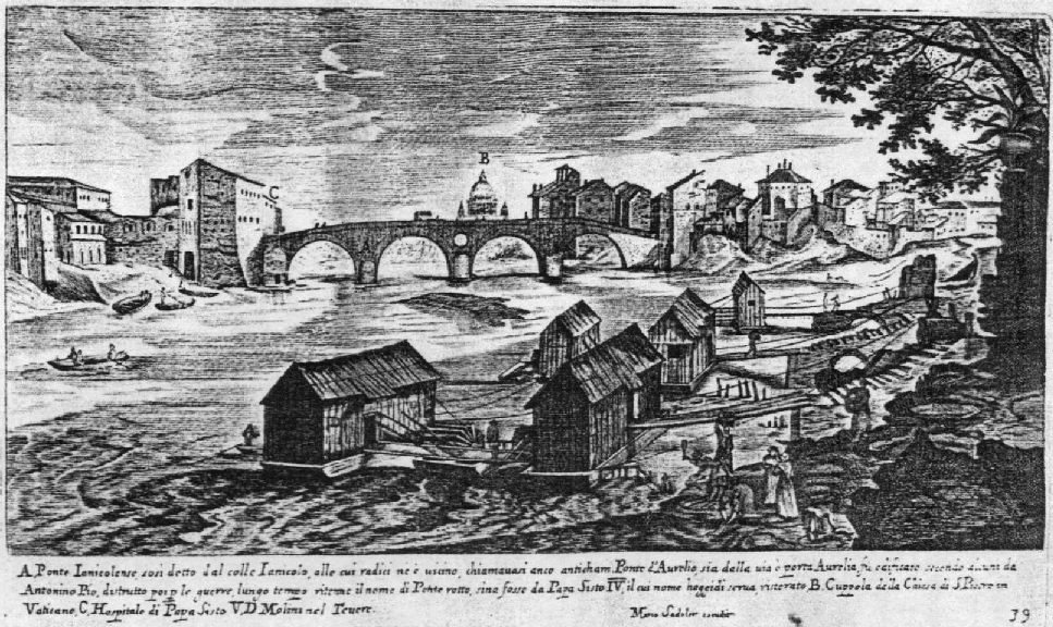
mills, all of them moored to the island, are shown.  Falda (1676)
(pict. C2) shows six mills, two moored to the island and
four to the right Trastevere bank; in the Falda map one
can also find two facing mills just downstream from
Ponte Rotto. Falda (1676)
(pict. C2) shows six mills, two moored to the island and
four to the right Trastevere bank; in the Falda map one
can also find two facing mills just downstream from
Ponte Rotto.  Nolli (1748)
(pict. C3) also shows six mills, three moored to the
island and two plus a ramp moored to the Trastevere
bank. These locations perfectly match those indicated,
two years before (1746), by Chiesa. Nolli (1748)
(pict. C3) also shows six mills, three moored to the
island and two plus a ramp moored to the Trastevere
bank. These locations perfectly match those indicated,
two years before (1746), by Chiesa.In the picture C4, an elaboration on the Lanciani map (1893-1901) are indicated the locations of the various mills obtained from the available documents.  The mills had names, often those of saints; a partial analysis of their locations, limited to the most recent ones, has been possible with the use of existing documents: the "brogliardi", the maps of the Pio Gregoriano land register, the daily "Specchi Dimostrativi" [Demonstrative Reports] (SD - see also para D) of the Supervision of Grinding and the works of Cialdi and Moroni. The mills were classified according to their administration: those moored to the island were in the administrative Custody of the Island, while those moored to the Trastevere bank were in the Custody of S.Bonosa.
In the "brogliardi"
and in the maps of the Pio Gregoriano land register
only the urban blocks are recorded;
|
||||||||||||||||||||||||||||||||||||||||||||||||||||||||||